
Geocaching is a real-world, outdoor treasure hunting game using GPS-enabled devices. Participants navigate to a specific set of GPS coordinates and then attempt to find the geocache (container) hidden at that location.
Geocaching
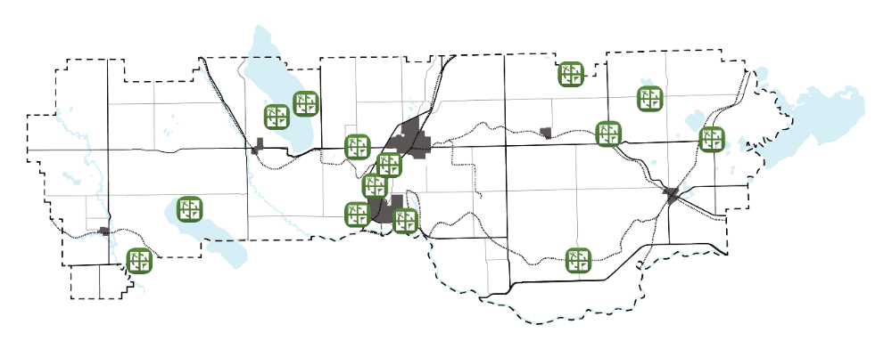
Lacombe County is home to a number of beautiful parks, trails, day-use areas, and other hidden gems - and we want YOU to come out and enjoy them through our geocaching program. To help you explore Lacombe County, we have hidden 15 geocaches in our boundaries, at many County parks, communities, and trails that we are proud to offer. We hope that after you visit these parks once, that you will return to them for a longer stay!
What do I need to go geocaching?
You will need a GPS device or a GPS-enabled phone so that you can navigate to the cache. You can also get a free Geocaching.com membership (if you want to find more than Lacombe County's caches), but we have posted the GPS Coordinates for our caches (below).
Don't forget to bring a pen to sign the log book, and a small trinket to trade (if you want to). You'll find that geocaching is fun for the whole family!
Where can I learn more about geocaching?
Geocaching has been around for many years. You can learn all about it at www.geocaching.com/guide, or search for "Geocaching 101".
Where can I find Lacombe County's geocaches?
If you're at one of our parks, day-use areas, trails or hamlets, there might be a geocache near you! We have hidden caches throughout the County at:
- Sunbreaker Cove boat launch (Sylvan Lake): N 52° 23.326 W 114° 11.578
- Ray's Pond (near Eckville): N 52° 19.389 W 114° 17.535
- Anderson Park (Gull Lake - 2 caches)
- Anderson Park Pollinator Gardens: N 52° 31.105 W 113° 56.357
- Anderson Park Trails: N 52° 31.194 W 113° 56.337
- Sandy Point Beach (Gull Lake): N 52° 30.294 W 114° 00.165
- Kuhnen Park (north of Blackfalds): N 52° 24.522 W 113° 48.028
- Mary & Cliff Soper Natural Area (east of Blackfalds): N 52° 22.503 W 113° 45.280
- Hamlet of Mirror Ball Diamonds: N 52° 27.708 W 113° 06.737
- Haynes Community: N 52° 19.055 W 113° 23.847
- Tees Fishing Pond: N 52° 28.298 W 113° 18.975
- TransCanada Trail: N 52° 26.022 W 113° 47.206
- Lacombe County Office: N 52° 28.000 W 113° 50.583
- Jim Gadsby Cairn (on Milton-Gadsby road, north of Tees): N 52° 31.267 W 113° 13.216
- Chain Lakes Day Use Area (north of Milton Road on RR24-3): N 52° 33.558 W 113° 23.080
- Directions: Turn east on Milton Road. Turn north on RR 24-3 and follow to the end, turning right on Township Road 41-4A, which provides access to a small recreation area maintained by Lacombe County on the western side of the lake
- Aspelund Industrial Park trails: N 52° 22.230 W 113° 50.580
Contact Us
Mailing Address:
Lacombe County Office
RR 3
Lacombe AB T4L 2N3
Physical Location:
40403 Range Road 27-4
Contact Us
Monday - Friday
8:00 a.m.- 4:30 p.m.
Email: info@lacombecounty.com
Phone: 403-782-6601
Fax: 403-782-3820
Stay informed!
Subscribe to receive news updates or follow us on social media to stay up to date on the County's activities, events, and operations.


